
Here’s another of our little map overlays. You can pause it any time you want by using the control in the top right hand corner.
The base map is from the UK Govt ‘Flood map for planning’, which you can find at this link. This is the map that the ‘ordinary man’ checks to verify whether or not their property might be at risk of surface flooding. If you take the link and have a play, you can look around and find areas well known for occasional flooding. The map’s reasonably accurate, unless, of course, you happen to be privately owned water utility trying to maximise the value of your land assets, in which case you can pay a private consultant to discredit the UK Govt map and substitute your own. Simple.


The second image overlays the proposed Portsmouth Water developments; the new office and car park to the north, and four proposed industrial units to the west.
In fact, the detail from the ‘UK Govt Flood map for planning’ is respected by your insurance companies, who will continue to load your home insurance policies based on the flood risk it predicts. This is something well known to our members who live in Manor Court, the homes at the bottom left hand corner of the map, who have been “told by our insurers that we are in a flood risk area and so we have had to take out additional insurance to cover.” Clearly, the evidence from their own window suggest that the insurance companies might have a point.

Let’s take a look from the other direction – Here are a few photos taken from the surgery over towards Manor Court.


And a few more looking northward towards the Portsmouth Water yards in Brockhampton Road and the current Portsmouth Water Company HQ buildings in West Street. We’d say that the UK Govt flood map is a reasonable representation of a factual risk.


Now just imagine concreting over large parts of that space to build a new office block and a large car park to the north of the surgery, together with a large area of industrial buildings and hard standing towards Manor Court in the west. All that surface water is going to have to go somewhere and we suspect that the insurance premiums on the Bosmere Medical Centre and the Manor Court homes will just take another hike.

So how could any right thinking local authority approve such a planning application?
We’ve been digging into the Flood Risk Assessment prepared by “I&L Consulting Ltd” that accompanies the application and it provides ample proof of the fact that if you can afford to throw enough money at consultants, you’ll get the answer you want:
“The current EA Flood Map shows that a large part of the site is located in land designated as Flood Zone 3 (high probability of fluvial flooding) and is shown as undefended. The north eastern corner is shown to be in Flood Zone 1 (low probability of flooding). The site is greater than 1 ha.
Portsmouth Water along with their consultant Ardent have submitted flood modelling and are undertaking flood alleviation works to the adjoining watercourse. This work is being undertaken under Environmental Permit licence number EPR/PB3294JJ. The works are underway and when completed the site will remain flood free during the 1 in 100 year plus climate change* scenario.“
This, of course, is great news for the residents of Manor Court and the staff at the Bosmere Medical Centre, who will be able to use this document to persuade their insurance companies to reduce their premiums. The new owners of the industrial sites, which Portsmouth Water need to sell off to keep their shareholder dividends up, will also be pleased that their insurance policies will be so low. (Oh… We’ve just remembered, the insurance companies use the UK Govt Flood map for planning… which is where we started.)
We were aware that the work is underway, in fact we reported on it in October last year when a planning application for ‘tree works’ was raised by Portsmouth Water, and duly approved by delegated responsibility by HBC Planning Services.
It’s high time that the council got to grips with Portsmouth Water’s planning shenanigans.
If you agree with us that this planning application should be refused, or indeed if you’re just one of the 20,000 Bosmere Medical Centre patients who are concerned for your own wellbeing and that of your medical staff, please click on the image below and comment on the application. Your voice counts.

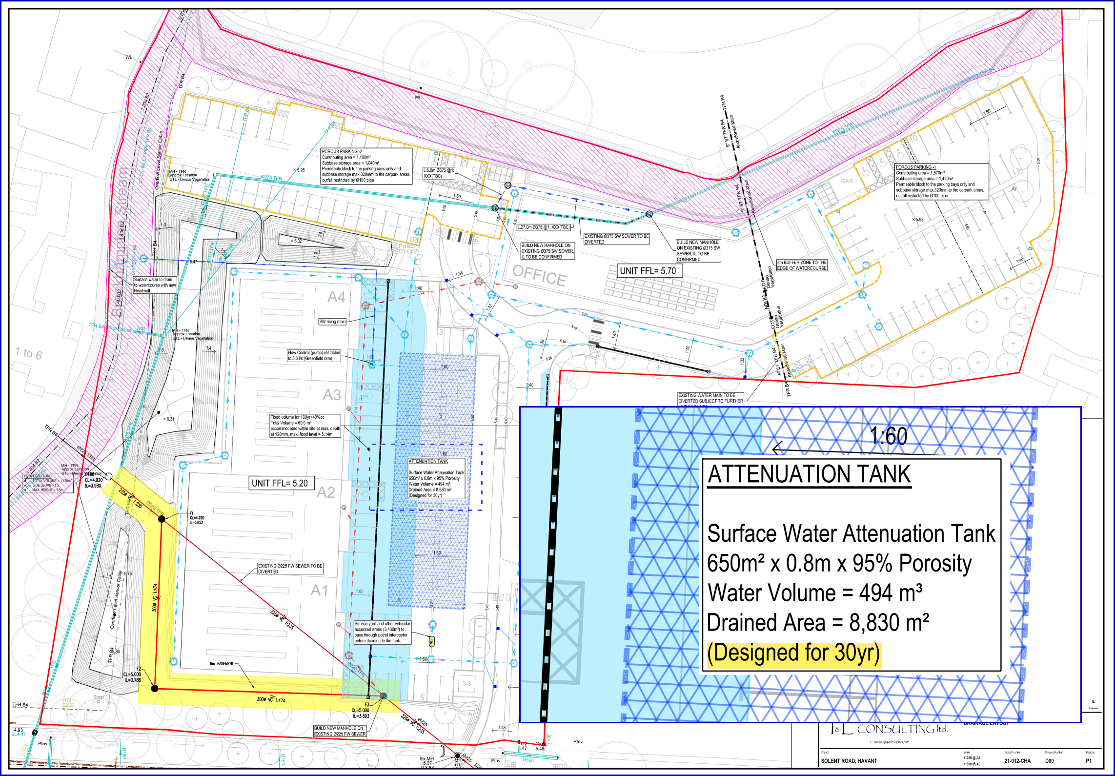
* The drainage layout actually specified by the consultant shows an attenuation tank designed for 1 : 30 year event so the consultant’s headline grabbing conclusion that “..when completed the site will remain flood free during the 1 in 100 year plus climate change scenario ” would appear to be some way from the truth.