
Regular visitors to this website will be well aware of our fascination with maps as illustrations for local topics of interest so the content of this post should come as no surprise.
Following on from the previous headline article in response to the technical “Assessment of the sea wall between Langstone Mill and Wade Lane”, prepared by Royal HaskoningDHV for Chichester Harbour Conservancy, we now take another look, first at the properties surrounding the Millpond and then at the foreshore and seabed. We had previously noted that the report was rather weak on considerations of land ownership, stating in several places that areas of interest are of ‘unknown ownership’. Given that those details are readily available, we consider what can and should have been deduced from a basic review of the sources available in the public domain.
The properties bordering the millpond
Our first point of reference here is the map included with the 1912 auction catalogue for the sale of land belonging to the Wade Court Estate. This lovely water-coloured map shows the parcels of land included in that sale, including the millpond and neighbouring properties. For a little more information on the Wade Court estate, please refer to this recent article on the estate published in the Winter 2020 / Spring 2021 issue of Hampshire Gardens Trust magazine.
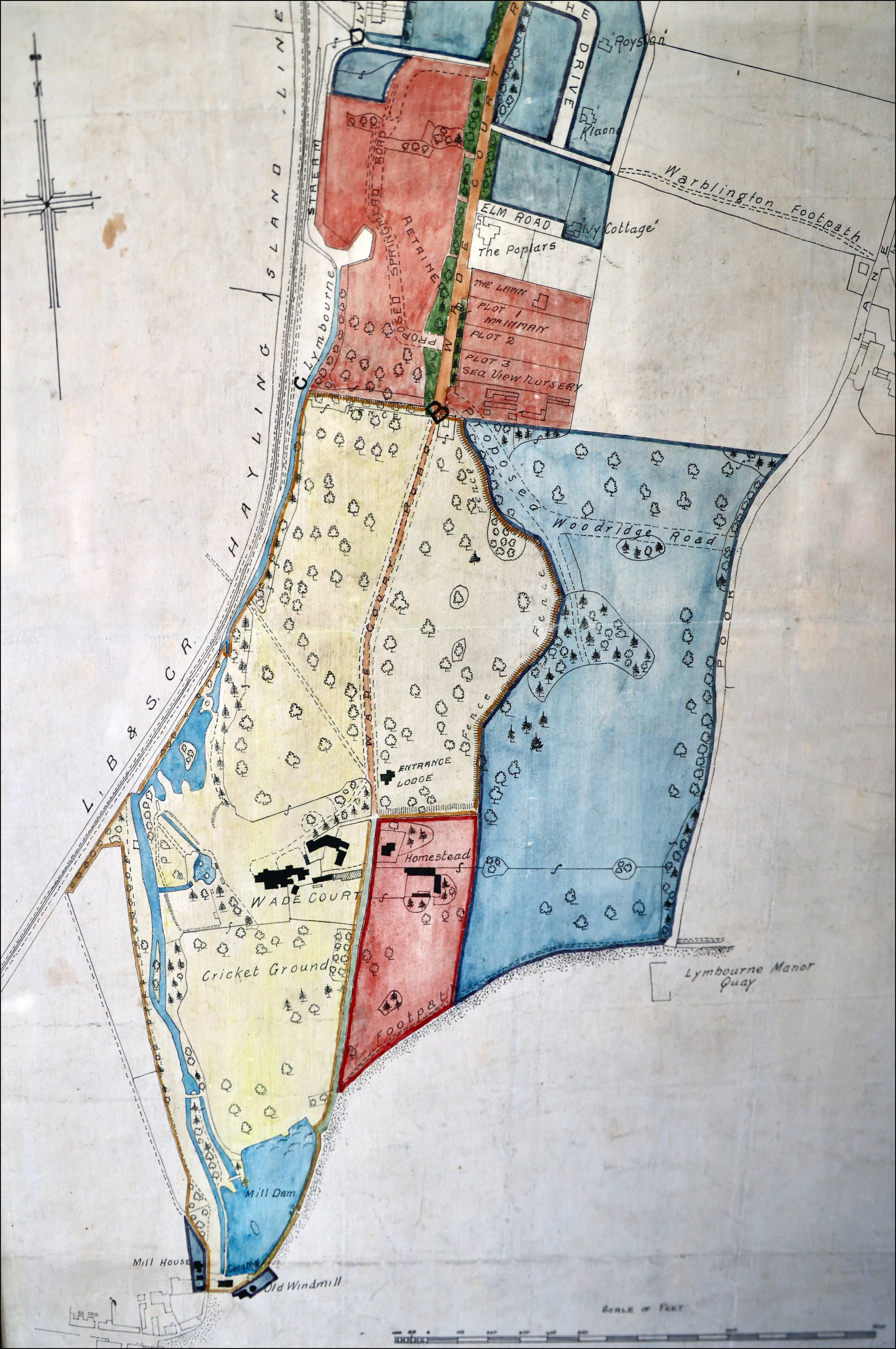
The auction catalogue itself contains details relating to the individual properties and in particular, for the properties bordering the millpond, notes relating to the responsibility of potential purchasers with regard to the provision of access for maintenance by the millpond owner of the pond and the Lymbourne stream. Looking at the current Land Registry title records for the same properties, it’s evident that the appropriate text from that auction catalogue survives, translated into clauses inserted into the individual title deeds.

On the left in this image is the former tidal watermill, now rendered cream and identified as number 21a Langstone High Street, also known as ‘The Boathouse’ with its small garden on the opposite side of the path. On the right of the image and under separate ownership is The Old Mill. A simple search of the Land Registry shows the two properties boundaries in context with the southern end of the pond.


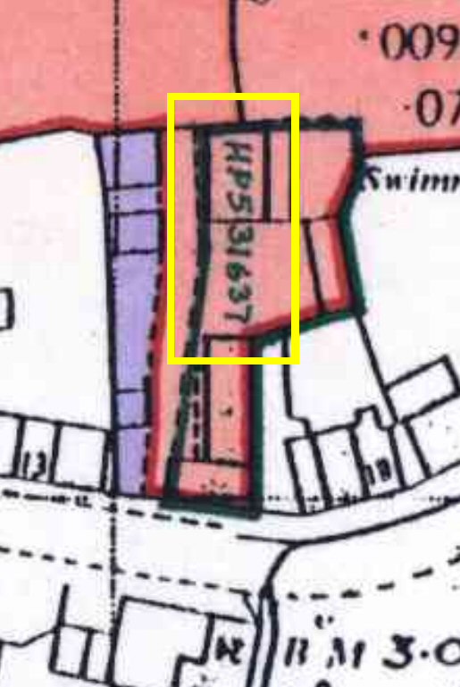
The Millpond, along with a stretch of the Lymbourne Stream, has a separate entry, ‘Land adjoining The Old Mill, Langstone’, registered with the same ownership as The Old Mill. The extent of the land holding is shown on the title plan outlined in red:
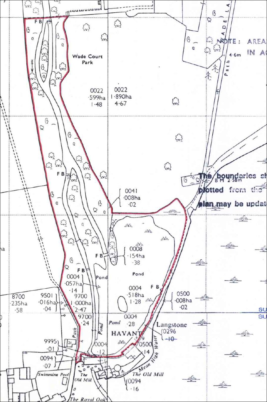
The title deed for the Millpond documents the owner’s ‘legal right of way at all times and for all purposes with or without animals and vehicles over and along the whole of Wade Lane and Wade Court Road ‘, providing that the property contributes to the ongoing cost of maintenance of those two routes. The summary title registration goes on to document the owner’s ‘legal right of way across [the map] … from the position of the end of Wade Lane where it strikes the sand and shingle on the foreshore to the north east corner of the land … for the purpose only of gaining access to the property with or without vehicles for repairing maintaining or improving the pond and streams situate on the property…’
A reciprocal clause in the title deed for the paddock confirms the right of access across the paddock to the millpond owner for ‘for vehicles required for the purpose of repairing maintaining or improving the pond and streams situate on Lot 3′ providing that 24 hours notice is given and any consequent damage to the ground of the paddock is made good.
These clauses were inserted into the original title registrations at the time the various lots which made up the Wade Court estate were sold off by auction in 1912. While the summary documents don’t suggest any obligation to maintain the pond and streams, the auction catalogue for the sale might offer a hint, buried in this piece of conveyancing jargon:
“The Lots are sold subject to all chief quit and other rents and outgoings and to all manorial rights and incidents of tenure rights of way, water, lights, drainage and other easements and rights of common (if any) affecting the same and all rights of adjacent owners and to any liability to repair or contribute to the repair of roads, ways, passages, bridges, sea walls, dykes, sewers, drains, gutters, fences and other like matters and subject also to the existing leases and tenancies and all allowances to and all claims for compensation and other rights of the tenants.”
Since there can be no pond without the dam, it should follow that the continued existence of the pond requires preventative maintenance of the dam, which in turn could suggest that the owner of the pond might be responsible for the preventative maintenance of the wall which protects the dam from the sea. (Only a property lawyer can pronounce on that one, all we’re doing is highlighting the information that exists in the public domain!)
The next three slides contain extracts from HM Land Registry records, with Langstone Meadows (shaded pink) to the west (left) of the image, the paddock (edged in red) to the north of the millpond and for completeness, Wade Court Farm (shaded blue) to the east of Wade Lane. According to the HaskoningDHV report (Sect 2.9) the maintainers of the sea wall between Langstone Mill and Wade Lane are unknown.
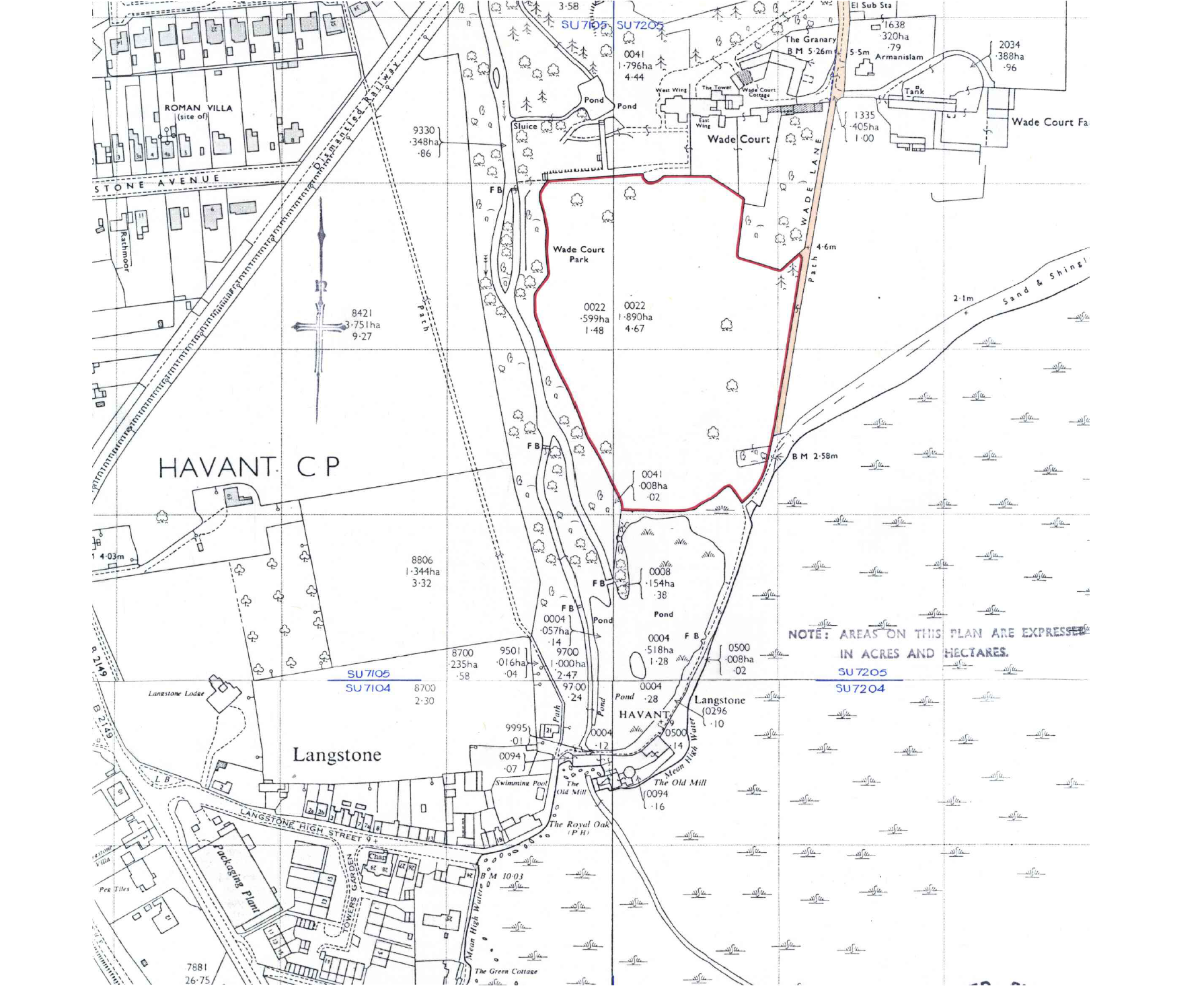


The first slide shows the paddock to the north of the millpond, marked out by a red line. This former part of the Wade Court estate is currently in the same private ownership as the equestrian centre in Pook Lane.
The second slide shows a large area tinted red which many locals will recognise as the meadow which runs between the Billy Track and the north side of Langstone Village including the well-trodden footpath which leads down to the mill buildings and The Royal Oak. Selecting a point right in the middle of the meadow, the documents identified in a Land Registry search shows the title of the register entry as ’15 Langstone High Street, Langstone’, which needs a little more explanation.

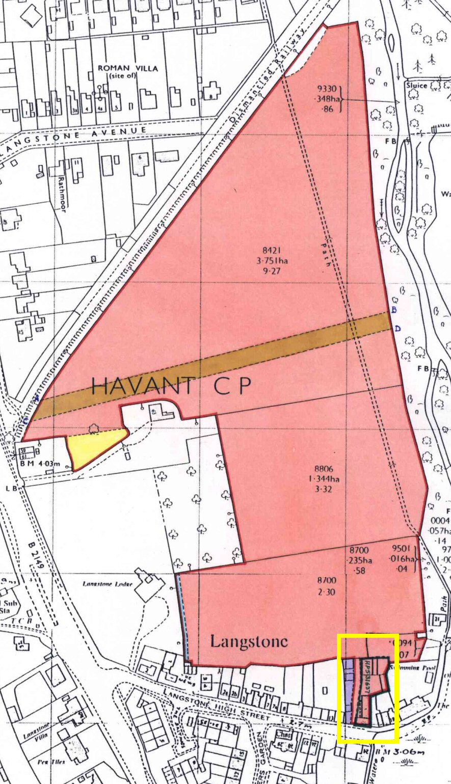

The actual building with that description, together with its outbuildings to the rear, may have been the ‘new’ farmstead for the Langstone Farm land, once the new railway had cut through the original Langstone Farm land. The ‘current’ Langstone Farm building was constructed to the east of the now sadly-destroyed ‘railway cottages’. A good long look at the detail in the Land Registry plan shows that the real ’15 Langstone High Street’, which has been in separate private ownership since 1997, has its own new title register entry under a new name. At that point, it seems that current registered owner of the entire red-shaded meadow became none other than Hampshire County Council.
The third slide shows the shoreline leading eastward from Wade Lane, towards Pook Lane. The area tinted blue is all under the ownership of Wade Court Farm.
‘The Langstone Channel’
While accountability for the maintenance of the wall is just one question exercising the current debate, the other question concerns the identity of the authority which calls the shots over any remedial action. While Havant Borough Council’s Leader has gone on record as an active supporter of the campaign to save the millpond, Chichester Harbour Conservancy currently claims the high ground. But is the Conservancy right? Let’s look at some more publicly available maps:
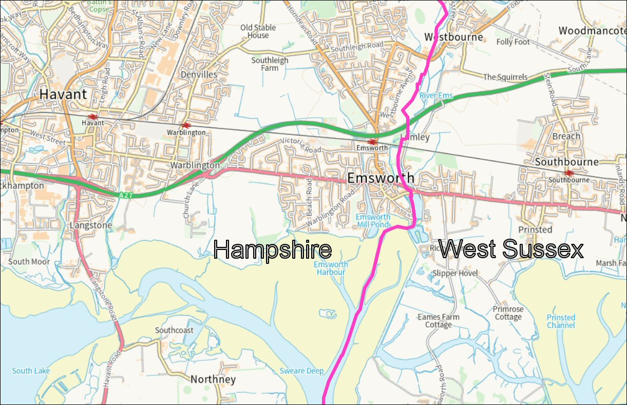
First, let’s take a look at the boundary between Chichester Harbour and Langstone Harbour. There is no single boundary between Langstone Harbour and Chichester Harbour, rather there are various definitions usually aligned to the access routes between Langstone and Hayling Island. Before any bridges were constructed, the Wadeway between Langstone village and North Common – marked on this 1870 Ordnance Survey map as ‘Causeway’ – seems to have marked the logical boundary between the two harbours.

When the Portsmouth to Arundel canal was created in 1820 the causeway was closed by the ‘new cut’ through the channel and the crossing point was blocked. In other maps we include later in this post, either the road crossing or the former rail crossing routes have been used as the harbour boundary lines.
The county administrative boundary for the land and the shoreline between Langstone Harbour and Chichester Harbour, including the responsibilities for planning, is further to the east, with the River Ems marking the county boundary at the shoreline.
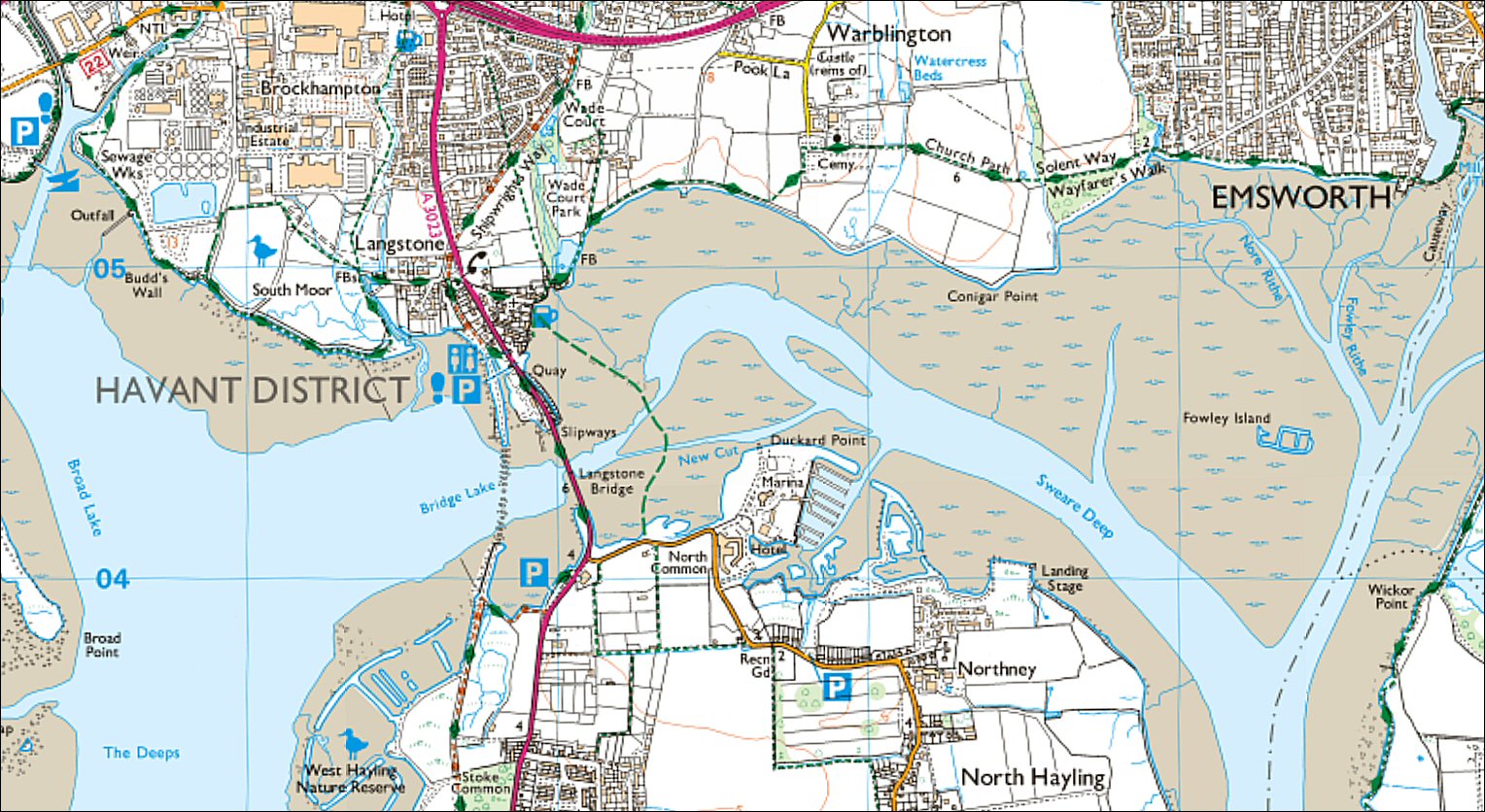
The local Ward Boundaries show the whole of the channel between Langstone and Hayling Island where we all expected them to be, firmly within Havant Borough Council’s authority – as it was back in the days of the Havant and Waterloo Urban District Council before some areas of the foreshore and sea bed were conveyed by HWUDC to the newly formed Chichester Harbour Conservancy.

For the purpose of discussion, let’s consider the channel between the two harbours, from Bridge Lake in the west, through New Cut to Sweare Deep in the east, forming a blended body of water bounded by the foreshores at Langstone, Warblington and Hayling Island, all within the administrative responsibility of Havant Borough Council.

As far as the environmental designations go, the real boundary is far less clearly defined than the hard boundaries drawn. There is transfer of water between the harbours in both directions at times during the tidal cycle, with a slight net westward movement of sediment in the channel. Hampshire County Council’s ‘integrated character assessment’ of the Havant and Emsworth Coastal Plain gives a useful environmental overview of the same area. (Click the map for details.)

The debate between Chichester Harbour Conservancy and Havant Borough Council over who holds responsibility for the maintenance of the Langstone Mill sea wall has less to do with the ownership of the shore-fronting land and more to do with the exercising of a game of environmental ‘Top Trumps’ – “My SSSI trumps your SINC”.
The map below is taken from Defra’s ‘Magic – multi-agency geographic information for the countryside’, a resource that geeky readers might happily lose themselves for many of the coming winter hours. In this case, note the hard and fast boundary between the ‘Unfavourable, declining’ waters of the Chichester Harbour SSSI and the ‘Unfavourable, recovering’ waters of the Langstone Harbour SSSI. While some might dispute the ‘Favourable’ status accorded to Southmoor, the clearly defined boundaries between the two harbour sites and Southmoor and Warblington Meadow SSSI may well be clear-cut. The clear split between the green and red areas, however, does look decidedly arbitrary. Note also that the Chichester AONB boundary in the second image defines its western edge as the Hayling road bridge, whereas the SSSI boundary is defined as the former rail bridge.


While we do appreciate the general argument that, in the grand scheme of things, coastal squeeze will have some negative influence on the state of health of the main body of Chichester Harbour, we feel that our millpond wall is being unfairly condemned. The negative influence of Southern Water’s appalling and long running discharges from its combined sewer overflows east of Thorney should offer better perspective on the balance of blame. Like most of the Havant borough residents, we dispute the Chichester Harbour Conservancy’s opinion of the influence of a 300 metre fragment of the 86 kilometre shoreline of what may, or may not, be defined as Chichester Harbour.
Land ownership
The foreshore and sea bed
Turning to the foreshore and the sea bed, an online search using the Land Registry mapping tool adds another intriguing dimension. From the bottom of Wade Lane, where the path turns eastward along the sea wall made up of old Hayling Billy railway sleepers, the title record for the section of foreshore and sea bed show that ownership of the area edged in red is with Chichester Harbour Conservancy. This area extends north of Sweare Deep as far east as the Emsworth Channel and appears to have been conveyed by Havant’s local council to Chichester Harbour Conservancy soon after the 1971 Act of Parliament which gave the Conservancy its remit. The record shows that:


Looking now to the west of the millpond, to the foreshore immediately to the west of the Mill, we see that the area immediately to the west of the gates to the Mill house is Crown Estate, subject to various leases for the benefit of (1937) Portsmouth and Gosport Gas Company, (1940) Urban District of Council of Havant and Waterloo, (1956) Portsmouth and Gosport Water Company and, again, (1966) Havant and Waterloo Urban District Council. A further lease dated 31 March 2010, expiring in May 2025, applies to ‘the land tinted pink which is granted in favour of Chichester Harbour Conservancy.

This leaves us with a gap on the shoreline map for which we’ve yet to identify the foreshore and sea bed ownership. Between the two areas shown above, in other words, for the full length of the Mill and millpond wall, there is no identified title record shown on the Land Registry search. Could it be that the foreshore and seabed there is still unquestionably the responsibility of the Crown Estates?
If it is, then perhaps we should ignore all the petty local, regional and environmental politics and go straight to the top to ask His Majesty for an opinion on what should be done to maintain this precious piece of the Havant borough shoreline?
If you found this of interest and share our concerns about
the future of Havant town and its environs,
please consider supporting us.
Take this link to find out more.
