
This year, we’re going to put the spotlight on traffic, given the evident disconnect between Hampshire County Council, Havant Borough Council and reality as far as traffic planning goes. This first of a series of posts sets out the background and provides context for the ones which will follow.
Understanding why Havant town has a traffic problem isn’t rocket science, in fact we first addressed the question in a post three years ago, entitled “Taking Responsibility for Traffic Management”.
The map of north Havant shown below is the Ordnance Survey revision of 1940. You can zoom into the detail at a larger scale by clicking the image.

The first thing you’ll notice is that back in 1940, the land which now includes Leigh Park, West Leigh, the New Lane employment area and the newer parts of Denvilles was still in agricultural use. New Lane was literally, just that, a small lane heading northward to ‘West Leigh Road’, which has long since been renamed Bartons Road, now straighter, wider and with a bigger railway bridge.
Now take a closer look at the bottom edge of the map and you’ll spot the level crossings at Southleigh Road and the bottom of New Lane (at that time named on the maps as ‘Gas House Road’). The central town level crossing that once joined North Street to Leigh Road has been blocked off by the new, longer station platforms needed to embark increasing numbers of commuting passengers. Replacing it is the brand new road bridge carrying Park Road North over the railway line, linking the town centre in the south to the agricultural land to the north, in preparation for the major post-war expansion of the town.
The image below is an extract from the 1933 edition, published just seven years earlier. Note that it shows the original level crossing at North Street and the allotment gardens on which New Road, Park Road North and Elmleigh Road had yet to be constructed. Notice also the station in its original position and the Hayling Line branch.

What these two maps clearly demonstrate is that eighty years ago, local authorities had broader powers and were staffed by strategic thinkers, enlightened town planners and experienced city engineers who planned, designed and built the essential service infrastructure before they built the housing and employment sites on which they depended.
Havant’s changing commercial transport hubs
Before the Second World War, local businesses were mostly supplied by rail to Havant Station, evidenced on the maps by the existence of the cattle market, the freight marshalling yard and the gas works close to the station. After the war, a comprehensive ‘local plan’ included the construction of Leigh Park to rehome many of the blitzed population of Portsmouth and the creation of the New Lane employment area to provide them with jobs. Given its location close to the railway station, at that time the main transport hub for the town’s commerce, the greenfield site at New Lane was the ideal place to build an industrial estate.

The migration of freight from the railway to the road network was helped by the construction of a new A27 bypass to the south of the town, centred on the Langstone roundabout and terminating in junctions with the old A27 at Bedhampton and Warblington. This road layout enabled the construction of new edge-of-town employment areas to the south of the town at Langstone, Southmoor and Broadmarsh, all with easy access to the national strategic road network.
The A3(M) was opened in 1979, providing a north/south bypass to relieve the growing choke point on the A3 at Portsdown Hill and to bypass the residential areas along the old A3 between Cosham and Horndean. While journey times between Portsmouth and London were greatly improved, the restricted designs of the Bedhampton and Purbrook A3(M) junctions, in combination with the limited number of fixed railway crossing points, began to isolate New Lane from the strategic road network.
The growth of traffic through these local choke points inevitably encouraged rat-running through residential streets as private cars and commercial vehicles attempted to find the least congested route. Access to the A3(M) junctions could only be gained by driving through the sprawling residential streets of Leigh Park to the west, while access to the A27 was constrained by the railway crossing points. Without a strategic bypass between the A3(M) at Horndean and the A27 at Emsworth, the former New Lane industrial estate was in effect ‘landlocked’ and starved of direct access to the strategic road network.
Access to the Strategic Road Network
The junctions linking Havant Town with the A27 and A3(M) are sensitive points on the strategic road network, not helped by restricted access at two of the busiest, the Bedhampton A3(M)/A27 junction and the junction of Purbrook Way with the A3(M). The following slides offer two views of these junctions, the “eye of the designer” view followed by an aerial view of the actual junction in the context of its surroundings.

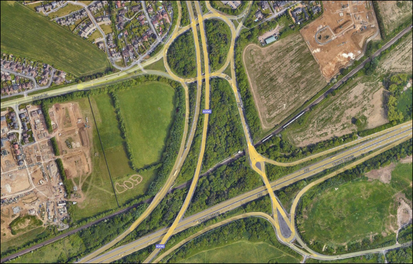


The Bedhampton ‘teardrop’ A27/A3(M) interchange is biased towards the ‘Portsmouth to London’ route. It is poorly designed for westbound traffic heading north, or southbound traffic heading east, forcing heavy volumes of ‘through traffic’ into this composite intersection. At peak times, this ‘through traffic’ acts against the junction’s equally important function as the strategic road network entry point for traffic from Bedhampton Hill, Farlington and Harts Farm Way.
The Purbrook Way / A3(M) interchange close to B&Q has limited access, so restricting its function as a major exit for the town and forcing northbound town traffic into the ASDA roundabout. This well-known Purbrook Way choke point should actually be considered as an extension of the Purbrook Way / A3(M) interchange infrastructure since it provides the only link, via Hulbert Road, to the first ‘full access’ A3(M) junction to the north at Waterlooville, conveniently sited for the new Dunsbury Park employment area. With a new Lidl store with parking for 132 cars under construction alongside B&Q, and the prospect of hundreds of new homes at Campdown, it won’t be long before the ASDA roundabout starts to struggle again, just a few short years since its last major rebuild.
The Langstone roundabout linking Park Road South and Hayling Island to the A27 suffers from frequent daily and seasonal peak volume traffic, now greatly exacerbated by the success of the Solent Road retail park. The recent lengthening of the eastbound slip road at the Park Road South entry to the Langstone junction is unlikely to make any material difference when the next hot day brings a flood of Hayling-bound traffic through the town.
To the east, the ‘dumbbell’ junction at Warblington has its own unique and complex set of problems and those will be considered in a separate HCS traffic post on the subject of the ‘The missing Southleigh link‘.
So where’s the ‘time-bomb’?
Despite Hampshire County Council’s commendable drive to improve cycling and pedestrian safety, the elephant in the room is the continuing growth in traffic volume along the A27 corridor between Portsmouth and Chichester, boosted by the lack of any coherent, boundary-spanning plan for housing developments and the rapidly increasing demand for 24/7, same-day home deliveries.
Emergency sewer repairs by Southern Water have recently provided a vivid demonstration of the vulnerability of the access roads onto Portsea Island, while barely a rush hour period goes by without reports of traffic piling up, often literally, on stretches of the A27 and the A259 around Chichester. The Fishbourne A27 roundabout desperately needs a flyover, while the A27 ‘dumbbell’ interchange at Warblington is already beyond its efficient capacity.
With no credible Local Plan for Havant Borough likely for several years and the region’s local planning authorities incapable of pushing back against questionable housing targets, developers continue to play the system, attempting to gain access, for example, to rich development pickings at Southleigh.
On the commercial front, Havant Borough Council’s irrational decision to permit the construction of Amazon’s DPO1 Portsmouth delivery station on the Wyeth-owned former Pfizer site at New Lane defied all logic and reason given the obvious unsuitability of the location. As DPO1 ramps up to full capacity, it will generate unmeasurable and uncontrollable volumes of traffic through the residential streets of Havant, inbound from and outbound to the strategic road network.
Whether the 32 New Lane planning decisions were influenced by ‘conspiracy’ or ‘cock-up’ remains to be seen, the jury is still out. What’s clear though is that neither Amazon nor the local authority are where they’d prefer to be. Well over £50M has changed hands between various parties at various stages of the deal, making the sub-optimal outcome an expensive mistake for somebody.
The network of new delivery stations designed to support the rapidly growing Amazon Shipping business is now emerging from the cover of anonymous planning applications across the UK. DBH3 was the first we positively identified nearby at Poole. When DBN5 begins operations in March 2024 at Bersted, southeast of Chichester, traffic on the already struggling A27/A259 system will get another jolt.
Meanwhile, New Lane’s DPO1 has the double distinction of occupying the least practical location while having the largest planned capacity of the UK sites identified to date .
The massive, multistorey ‘van parking decks’ constructed at each of the nodes of Amazon’s new delivery network have yet to be activated. Once that happens, the real traffic generation profile of these sites will start to become clear, and with the Amazon Shipping business growing fast, it probably won’t be long.
As an aside, an intriguing addition to the Amazon Shipping fold that we’ve recently spotted is Photobox, previously a well-known Royal Mail customer. Kingfisher/B&Q, eBay and others have already bought in and the big prize of Royal Mail deliveries must surely be firmly locked in Amazon’s sights.
To build a better future, HBC must first defuse the bomb
The validation and approval of the two Amazon 32 New Lane planning applications demonstrated without any doubt “the disconnect between Hampshire County Council, Havant Borough Council and reality” mentioned in the heading paragraph of this post. HCS has reported on a catalogue of individual planning applications over the past five years for which there has been an abject failure to take into account the cumulative impact on traffic of individual planning applications. Without urgent attention to current and future traffic management, the Local Plan currently under development is liable to suffer the same fate as its predecessor.
In order to provide the solid foundation essential for Havant’s new Local Plan, we believe an ‘A27/A259 traffic summit’ should be convened, with representation from:
1 – Havant Borough Council
2 – Chichester District Council
3 – Arun District Council
4 – Hampshire County Council
5 – West Sussex County Council
6 – National Highways
7 -The residential and small business communities
Coming next:
The next post on Traffic will consider the current load on the A27 Warblington interchange and the critical need for the ‘Southleigh A27 Spine’ road.
Credits:
A3(M) graphics roads.org.uk.
Map images licenced from National Library of Scotland map archive.
