
Updated 18/4/2021 07:00
Background to this article
A planning application is under review for an unnamed international warehousing and distribution company to set up a ‘last mile delivery’ operation at the former Pfizer site in New Lane. The 24/7, three shift operation will provide the base for more than 800 delivery vans servicing Hampshire, Sussex and Surrey, generating well over 5,000 vehicle movements each day of the week.
This is a long read in five related sections. If anything in this article strikes a chord with you, skip to the bottom, and write to your councillors. There’s a link there to help you find their email addresses.
To skip directly to a section, take one of these links:
- HBC’s lack of focus on traffic
- Traffic – What’s the problem?
- The railway bottlenecks – From Bedhampton to Bosham
- The future of New Lane
- Postscript for HBC Councillors
HBC’s lack of focus on traffic
The current planning application for the former Pfizer site at 32 New Lane has raised a storm of objections over the inevitable impact that the development would have on town traffic. Each of those objections stands on its own individual merits but a recurring theme throughout is concern for the increased danger to cyclists and pedestrians, from school age to the elderly, from such a significant increase in traffic movements on residential streets. This additional traffic and its inevitable pollution will directly impact the three primary schools within a mile of the site. Sharps Copse Primary to the north, St Albans Primary to the west and Fairfield Infants to the south.
When the Council announced its new constitution in January, it predicted that it would “make the operation of the council more agile, cost effective and able to respond to the needs of the community.” The Constitution itself defines a role of “Cabinet Member with Portfolio Responsibility for Traffic Management”, but the fact that no Councillor is named in that role in this current Cabinet demonstrates the lack of priority given by HBC to the impact of traffic.

This is not the first time that ‘Consultee Traffic Team’ has failed to recognise that Havant has a problem with traffic. In fact, we’ve seen this exact same response on previous occasions, word for word, right down to the email address which still returns mail as invalid. These consultee responses are sloppy, but they’re not the fault of ‘KRC’, who probably works out of East Hants District Council with objectives that cover little more than parking and closing a few roads for Remembrance Day. Without any clear Cabinet oversight of the job, the ‘Traffic Management Team’ – if they actually exist – clearly flounders.
So what’s the problem?
Understanding why Havant town has a traffic problem isn’t rocket science. The problem stems from the growth of the town around the fixed railway infrastructure that once formed the town’s transport hub.
The migration of freight from the rail network to the road network over the past sixty years has resulted in the construction of a brand new strategic road transport hub, out of town to the south west at Broadmarsh. New employment areas have been built alongside the A27 and the A3(M), enabling rapid connection between the employment areas and the trunk roads, with minimal impact on the town traffic.
In the 1872 map, below, the railway network is clear, with Havant Station in the top right hand corner. The second image, from Google Earth, overlays the new trunk road infrastructure.


As the area to the north of the railway becomes increasingly residential and personal car ownership continues to increase, the bottlenecks formed by the five railway crossing points present challenges for journeys outbound to, and inbound from, the A27 and the A3(M). With no high volume traffic route between the A3(M) at Horndean and the A27 at Southleigh, the former New Lane industrial estate is now landlocked by residential development and starved of efficient access to the national road network.
The ‘railway crossing’ bottlenecks
| Park Road North road bridge | Constraints: Uninterrupted by train movements – Single lane vehicle approach, two lane exit In brief: This crossing is heavily congested at peak times, weekends and holidays due to downstream congestion at Langstone Roundabout, Elm Road junction and Solent Road junction. There is increasing congestion associated with home delivery and ‘drive thru’ traffic generated by the four main fast food outlets sited on Park Road South. |
| Bartons Road road bridge | Constraints: Uninterrupted by train movements – Single lane each way In brief: The bridge of choice for ‘the back road to Chichester’, heavily used at peak times by traffic avoiding the congestion at the A27 Chichester bypass rounadabouts. The nature of the traffic flow over this bridge will change considerably once the Southleigh A27 Link is built since that will provide the quickest uninterrupted route to an A27 junction for a large area of Havant. Furthermore, if ‘traffic generating’ businesses continue to be tolerated or are allowed to grow at the New Lane employment area, then this crossing will become the route of choice for access to the A3(M) via the Comley Hill, Whichers Gate, Horndean rat-run and to the A27 via Southleigh. |
| New Lane level crossing | Constraints: Closed for all trains on the London line and Brighton line In brief: Frequent traffic tailbacks across New Lane/Eastern Road junction to the north, and across the Fairfield Road/Waterloo Road junction to the south. |
| Southleigh Road level crossing | Constraints: Closed for all trains on the Brighton line In brief: Frequent tailbacks blocking access to residential properties and Warblington School. With the New Lane / Eastern Road / Elmleigh Road rat run closed , this crossing may now be favoured by LGV traffic heading to A27 E/W at Warblington. |
| Bedhampton level crossing | Constraints: Closed for all trains on the London line and Brighton line In brief: Extended closure at times due to the short platform when long westbound trains stop at Bedhampton Station. Peak time local hold ups for commuter traffic to and from Southmoor Lane / Harts Farm Lane. These peak time problems will not be helped by the long term development plans for the Portsmouth Water estate bounded by West Street, Brockhampton Road and Solent Road, information about which is murky at best. |
And further east?
Travel on eastward towards Bosham on the A259 and what do you see? All the way from Emsworth, through Southbourne and Nutbourne, a ribbon development of new housing crammed in south of the railway to help Chichester District Council meet its own housing targets. Constrained by the level crossings at Southbourne, Nutborne and Bosham, much of that new population will be driving to and from the nearest available A259/A27 junction, at Warblington.
Once the Southleigh A27 link (Option 1B) is open, just how well will the Warblington A27 interchange cope? (Answers, on a postcard please, to trafficteam@havant.gov.uk.)
New Lane – Looking to the future
Sixty years ago, New Lane led Havant’s growth with the likes of Kenwood, Goodmans, Colt, Scalextrix and Britax. The quality and reliability of the West Leigh workforce with their famous ‘We’re backing Britain’ campaign encouraged IBM, Plessey, BAe and Siemens to invest in the Borough. As a regenerated employment area providing sustainable jobs within easy reach of the town centre bus and rail hubs, New Lane should have a great future.
Those famous manufacturing brands that were once synonymous with the New Lane estate have mostly moved offshore, with only Kenwood retaining office, shop and warehouse space on the site. Given its increasingly urban context, the site is now far better suited to businesses with sustainable day-time working and commuting patterns, ideally providing the local residential community with the higher skilled employment opportunities promised by Havant’s Regeneration Strategy. Eatons, Kenwood and Dunham Bush are all long established ‘good neighbours’ and with the opening of the corporate headquarters of Anetic Aid and more recently the new UK site for Sartorius, the potential for the right sort of growth is clear.
Businesses that generate traffic movements in excess of normal daily commuting should be actively discouraged and ‘managed out’ by Havant Borough Council, while office-based employment, technology based manufacturing and the type of high value, secure storage opportunities associated with the Solent Freeport should be encouraged. The Spring Business Park under construction on the former Butterick site, with Qvis CCTV and Security a convenient neighbour, could be readily adapted to support Havant’s Freeport opportunity,
A coherent strategy for the management of Havant’s traffic is the key to unlocking the potential of New Lane while at the same time reducing the peak time traffic which chokes the town’s road network. While the real authority on highways and traffic lies with Hampshire County Council’s Highways Authority, much closer liaison between the Borough and County council is required if we are to keep control of our streets and keep the traffic moving. The role of “Cabinet Member with Portfolio Responsibility for Traffic Management” should be recognised for its importance and should be filled with an appointee with vision.
Postscript for HBC Council Members
The decision on this application is critical to the future of Havant. The wrong decision will simply exacerbate the existing traffic problems, will endanger the safety of residents and their children, and will deny the New Lane employment area the opportunity for the type of regeneration that will secure its future growth. The right employment profile will bring the business opportunities that lift educational standards across the Borough, just as the high tech businesses which followed New Lane’s first wave in the 1960s did.
A great many hours have been spent drilling into the documentation which accompanies application APP/21/00200, in order to arrive at an adequate level of understanding. For those elected representatives in decision making roles, the following paragraph from the Planning Code of Conduct is particularly relevant:
“Do come to your decision only after due consideration of all of the information reasonably required upon which to base a decision. If you feel there is insufficient time to digest new information or that there is simply insufficient information before you, request that further information. If necessary, defer or refuse.”
The Transport Statement provided by the applicant is ‘topped and tailed’ with a soft, marketing spin that should not be taken at face value. The language in the ‘Summary and Conclusions’ is loose and the data within the document contains many inconsistencies and selective omissions. It is presented, as might be expected, in a manner supportive of the Applicant’s case so I would urge you to study this in depth.
An exhaustive critique of the document set would be a dry read indeed, so please just consider these two examples from the tables in the main document. This should give enough of a guide to the accuracy of its conclusions.

The first point to note in both of these tables is that the data shown covers a single one hour ‘peak’ in the morning, a one hour peak in the afternoon, and a total daily figure. The application is for ‘3 shift operation’ over a 24 hour day, 7 days a week, therefore the periods selected for these comparisons are not representative of the true impact of the business on the town’s environment.
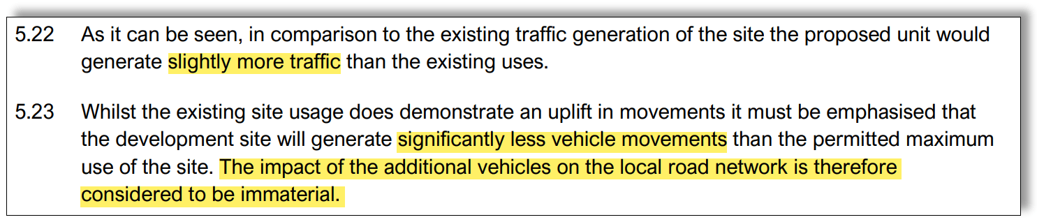
Table 5.4 is used to demonstrate that, compared “to the previous maximum usage of the site the proposed development would generate less traffic both during peak hours and across the day”. That’s very convenient but also rather misleading since the ‘Previous Maximum’ numbers are theoretical, assuming the traffic that might be generated if the site were used to the maximum extent allowed under the planning permissions currently in place. This theoretical decrease of just 90 daily vehicle movements is referred to in the document as “significantly less vehicle movements”.
Table 5.4 is then used to demonstrate that the proposal would result in a decrease in both morning and afternoon peak hours of the existing site traffic, while only adding “an uplift of movements” to the overall daily total. This increase of 466 vehicle movements is referred to in the document as “slightly more traffic”. The residents of New Lane, who have lived with the operation of ‘the existing site’ for many years, question the veracity of the ‘existing site’ numbers quoted since they bear no resemblance to observed reality.
Not only are the authors of the Transport Statement creative in their use of English, but their basic mathematics is also equally loose. A nit, repeated too many times to be a typo, is their constant quoting of 2,415 vehicle daily movements. According to us, that’s slightly at odds with the source numbers for the proposed use provided in Appendix F, ‘Occupier Traffic Data’. That data source is a simple table that predicts actual movements arriving and departing from the site over a 24 hours period, based on the intended occupier’s existing sites across Europe (listed in appendix H).
We can safely assume that this data source represents just the HGV and LGV movements since there is no evidence in the data for the three shift staff commuting patterns the intended occupant proposes. Staff arriving for, and leaving at a midnight shift changeover will not be using public transport.
We looked at the occupier data and drew up a rather different picture:

The blue data is taken directly from Appendix F and shown for each hour of the day. The grey data includes the additional movements of the van drivers, arriving in their own cars in the morning to pick up a van and leaving at the end of their shift having dropped their van back in the vehicle storage unit. The yellow data assumes that there are 208 staff on site at any one time in the 24 hour day, with three shifts changing over at midnight, 08:00 and 16:00. Since the employee numbers, while clearly available to the applicant, are withheld in the paperwork, we’ve made a reasonable assumption that the 208 parking spaces allocated in the design are used by the warehouse work force. We know from elsewhere in the document that the van drivers will be parking their personal vehicles on the ‘van storage decks’.
In summary, the Transport Statement supplied in support of the application is at best, creatively misleading.
To view an earlier post containing a further selection of misleading ‘facts’, please take this link.
Please read deeply and consider the much wider implications of this application. The right decision will open the opportunities for regeneration that the town needs. The wrong decision will be remembered for a generation.
Take the links from this page to find their email addresses.
If anything here strikes a chord, write to your local Councillors.

#rethinkhavant
