
A few weeks ago, we reported on the Planning Committee decision to approve Foreman Homes’ proposal for the development of 120 homes on former Portsmouth Water land at Kingscroft Farm. Throughout that Planning Committee meeting, ‘ransom strips,’ ‘unadopted roads,’ and ‘disputed ownership’ were frequently mentioned, so we believe an explanation might be helpful.
The task of constructing that many high-quality homes in a remote area of Havant once allocated for commercial development presents many challenges due to the access arrangements forced on the developers by the former landowner’s use of ransom strips across its estate. The unusual nature of the Kingscroft Farm site access arrangements and the responses given to questions raised by the Planning Committee warrant closer examination.
Councillor Tanson was the first to raise this issue, inquiring why the development site (‘A’) could not be accessed via Marples Way (‘B’), see the following map.

It’s worth taking a few minutes to listen to the recording of the planning committee from that point on by clicking on this link. Stick with it for a few minutes and you’ll hear first Councillor Hagan and then Councillor Lind querying efforts to prevent vehicle access from Meyrick Road to Ranelagh Road (‘C’). The HBC Planning Services case officer’s response summarises two options available to Hampshire County Council Highways which would prevent vehicles from accessing the Kingscroft Farm development site through Ranelagh Road. HBC Planning Officer Steve Weaver steps into the shoes of the case officer and provides a lengthy yet inadequate response before Councillor Keast goes one step further and suggests that it would be nice if the residents of Ranelagh Road could have some say in the matter.
Councillor Robert and Councillor Hulls both raised risks associated with the future maintenance of the culvert, which runs beneath the line of the site access road.
As Councillor Horton had already noted, it would be a whole lot easier for everyone if the Kingscroft Farm site could have been accessed from Marples Way.
Elsewhere in the meeting, Councillor Hulls questioned the amount of effort that had been put in to explore the redevelopment of the site for commercial employment purposes rather than housing, as had been the original intention in the last Local Plan. He put it quite succinctly, suggesting that one half-hearted attempt to market the land six years ago hardly showed any strong level of commitment by Portsmouth Water to sell the land for much needed employment use.
‘Unadopted roads’ and ‘disputed ownership’
These two terms occurred widely throughout the discussions and debate at the Kingscroft Farm Planning Committee but the question arises rather more widely across the area. The HCC ‘Unadopted street search’ tool, shows the ‘unadopted streets’ in the wider area. They are the ones not highlighted in colour on this map.

Residents of unadopted streets are still required to pay full council tax, but they don’t benefit from public maintenance services. The upkeep of unadopted streets falls entirely on the property owners whose homes front the road which can lead to disputes over the costs and standard of maintenance.
To get an idea why these Bedhampton streets have not been adopted by HCC Highways, we need to look a little deeper. On the Land Registry title plan below, the Portsmouth Water land edged in red includes two areas marked in green, showing plots of land sold on and transferred, including the area in the middle of the image now occupied by the Abrams Way development. Note, however, the area edged in blue, being Nos. 1 and 1A Ranelagh Road; a two storey property fronting the road but still owned by Portsmouth Water.

Below and to the left of the green-edged land on which the Abrams Way development has now been built, you can see one of the parcels of land now being transferred to Foreman Homes for the Kingscroft Farm development.
The Marples Way ransom strip
Councillor Tanson and Councillor Hulls were quite correct, it would have made far more sense if the Kingscroft Farm land was developed for commercial employment purposes and was accessible through Marples Way, but here’s the rub, Portsmouth Water deliberately left a ransom strip in the way.
That ransom strip, the thin piece of land edged in red, is visible in this next title plan from the Land Registry.

This classic ransom strip is sandwiched between the land sold to Foreman Homes and the land on which the ‘Fatface’ office stands. Any prospective developer of the Kingscroft Farm land who wanted to use Marples Way to access the Kingscroft Farm site would have to pay a significant ransom to Portsmouth Water to gain access.
Since the farmland was more valuable to Portsmouth Water if sold for housing, it’s hardly surprising that efforts to sell it for commercial use were half-hearted. While the right commercial developer might have paid the ransom, rarely would a housing developer have taken such a hit on its profit.
Perhaps the more interesting question would be to ask why Havant Borough Council has not used its compulsory purchase powers to acquire the strip. It’s not without precedent and is certainly possible.
Remember Palk Road?
It seems that unadopted roads, ransom strips and questions of disputed ownership appear quite regularly with development proposals on the Portsmouth Water estate. Palk Road, directly to the north of Kingscroft Farm at (‘D’) on the map, where Bellway Homes resubmitted its planning application for 83 homes in February, is the subject of a long running dispute between HCC Highways and the applicant over the access road which is now the subject of a Section 278 detailed design process.
While this image of the Palk Road development proposal is new, little else appears to have changed from the scheme presented at the Development Consultation Forum back in 2022.

Don’t forget the Bosmere Medical Centre
While not technically a ransom strip, the long running planning application for a swanky new HQ building for Portsmouth Water is being used by the company to similar effect. When Bosmere Health Limited bought the plot of land at (‘E’) on the map from Portsmouth Water twenty years ago, it seems that the Company enabled access to the medical facilities from its land to the west, one assumes to help by maximising the available parking.
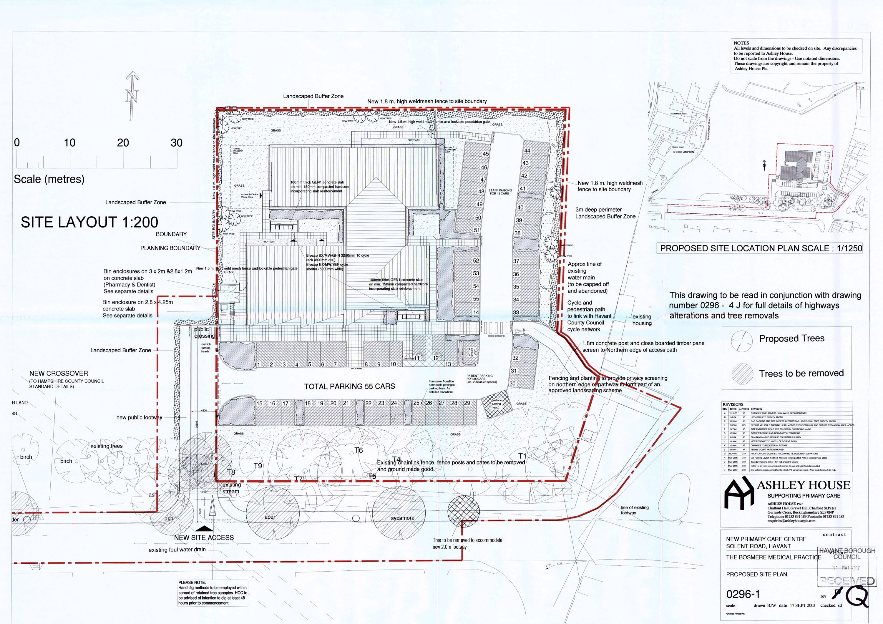
Back then, long before Ancala bought the company, Portsmouth Water’s reputation was still in good order and its local credit high. Twenty years on, the company’s attitude to its neighbours and the population of the borough has changed, driven by the commercial imperatives of its private owners and its unfortunate financial dependence on Southern Water to support the construction of the Havant Thicket Reservoir.
Twenty years of continuous exclusive use by the two separate healthcare facilities on the Bosmere site, with the pressure of continued growth in the patient list, has left the staff of both units, their landlord, the 20,000 patients and other residents dependent on the pharmacy, reliant on the continued and uninterrupted use of that access.
The existing entrance to the healthcare facilities is not classified as a ransom strip under planning regulations, nor is its ownership contested by the current user. However, the proposal by Portsmouth Water to transform this entrance and turning area into a through road, with no consideration given to the essential needs of the existing site users, is widely perceived as the company leveraging its status as a significant landowner.
Portsmouth Water possesses several alternative access routes, raising the question of why Havant Borough Council has chosen to overlook the evident gaps in the planning application’s accompanying documentation.


Excellent update
LikeLike